NASA-ISRO's NISAR Satellite Captures Stunning 'Hummingbird' Image In Antarctic Ice
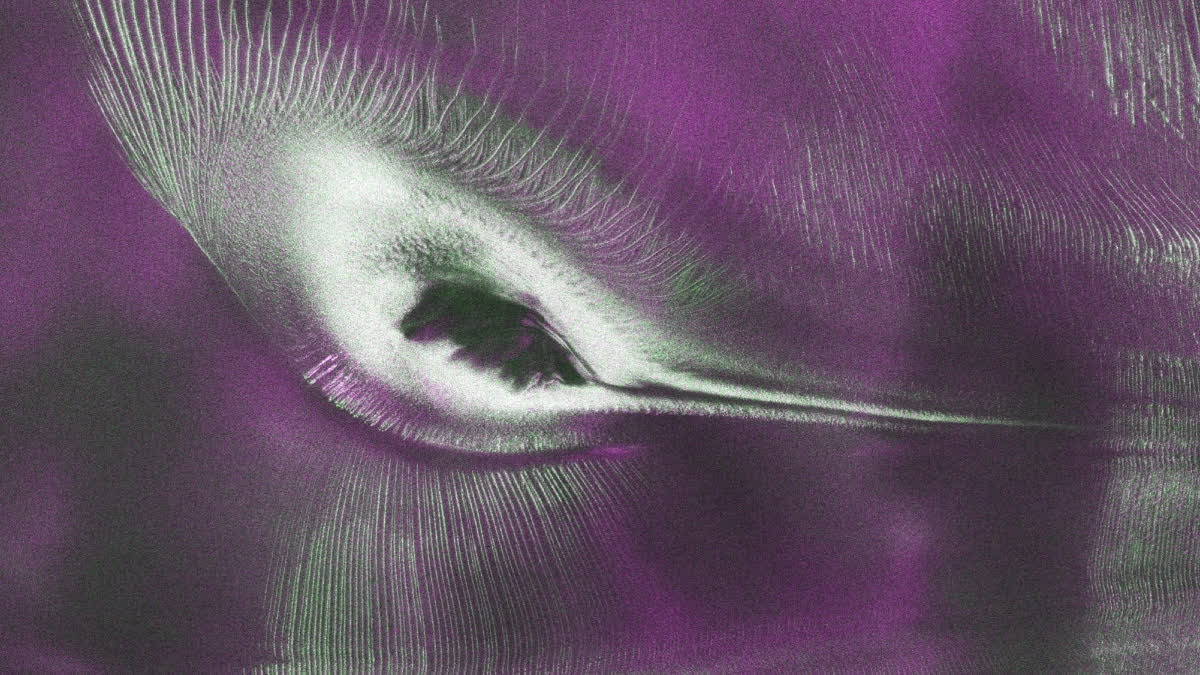
By Global Science JournalHyderabad: The NASA-ISRO Synthetic Aperture Radar (NISAR) satellite, a joint mission by the United States’ (US) NASA and India's ISRO, has released a striking radar image of Antarctica that bears a strange resemblance to a hummingbird, delighting scientists and the public alike.
The picture, created using data from NISAR's L-band radar, shows Nunatak Zaterjavshijsja, a mountain peak in East Antarctica situated within a northeast-flowing ice stream.
How was the image formed?
In East Antarctica, the moving ice collides with the mountain peak, which builds up pressure that causes deep cracks, known as crevasses, to form on the surface. These cracks appear as sharp green lines resembling a bird's wings, prompting scientists to nickname the formation ‘Hummingbird’. The data was collected in August 2025 while mission teams were testing the satellite's systems, and has now been made public as NISAR approaches its first year in orbit.
The science behind the colours
The vivid colours in the image result from how polarised microwave signals bounce off the ice. NISAR transmits horizontally polarised radar waves over Antarctica, and the way these waves return reveals the nature of the surface below. Signals returning with horizontal polarisation, typical of smooth ice, appear magenta, while signals returning with vertical polarisation, caused by uneven surfaces such as crevasses scattering the waves, appear green, a process known as volume scattering
Areas showing both effects strongly appear white. Notably, a standard optical camera would show little more than plain white snow, with hills barely visible through faint shadows, highlighting how radar imaging reveals far more structural detail than conventional photography.
Why does the data matter?
Glaciologists can use such radar data to map crevasses and ice shelf boundaries, helping them understand how quickly ice sheets are moving and how they might respond to rising temperatures. East Antarctica remains far less studied than West Antarctica, despite holding enough ice to raise global sea levels by tens of metres over coming centuries if it were to melt. Continuous monitoring of features like this could therefore improve estimates of ice loss.
A first-of-its-kind mission
NISAR is the first free-flying space mission to combine two radar systems, L-band and S-band, which complement each other through their differing wavelengths — the L-band can penetrate tree canopies to image the ground beneath, while the S-band gathers information about the canopy itself.
India's team at ISRO's Space Applications Centre in Ahmedabad has begun releasing S-band data via the Bhunidhi portal. The mission is overseen by Caltech, with the Jet Propulsion Laboratory building the L-band radar and reflector antenna, at 12 metres wide, the largest ever flown in space, while ISRO built the rest of the satellite and its S-band radar. The NISAR satellite was launched on 30 July 2025 from the Satish Dhawan Space Centre in Sriharikota..